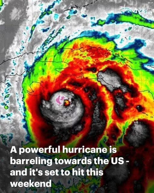
Having just been categorized as a Category 2 hurricane, Hurricane Rafael, an unusual storm for November, is getting stronger and moving toward the United States with significant force. Rafael is an uncommon and potentially dangerous hazard for this time of year, especially affecting regions from Texas to the Florida Panhandle, with maximum sustained winds of 110 mph. According to the National Hurricane Center (NHC), the storm is expected to make landfall in western Cuba within hours, making it one of the first areas to feel its effects. Communities throughout Cuba and the southeast United States are on high alert as a result of this crisis.
For areas along the storm’s anticipated path, such as the Florida Keys, where projections indicate up to three inches of precipitation and a high chance of tornadoes, the NHC has issued hurricane warnings. There is a serious risk of flash flooding in low-lying places, especially since Rafael might get stronger before crossing the Gulf of Mexico. Residents in the Florida Keys and Gulf Coast regions are encouraged to stay informed about the most recent advisories and should brace for significant weather disruptions, according to NHC authorities.
Rafael may undergo what meteorologists call “rapid intensification” as it moves across the warm Caribbean waters, which is defined as a rapid rise in storm winds, especially when the ocean temperature is high. The Gulf’s waters are warmer than normal this year, which could give the storm more energy and accelerate its growth. Rafael has the potential to become the strongest storm to hit the northwest Caribbean in November since 2009. Before the storm makes landfall, meteorologists are closely observing its path for any indications of increased intensity.
In the event that Rafael’s trajectory suggests a more direct threat to populated areas, local officials in the Florida Keys and throughout the Gulf Coast have begun preparing for potential effects by bolstering infrastructure, setting up emergency shelters, and allocating resources for potential evacuations. In certain counties, companies and schools are creating backup plans, and Florida’s Department of Emergency Management has begun working with local organizations to guarantee readiness. In preparation for potential evacuations, residents are advised to gather emergency supplies, fill up their cars, and protect their homes, especially those in flood-prone locations.
Many Floridians are still recuperating from previous hurricanes this year, so the prospect of another hurricane is especially frightening for both locals and emergency personnel as they get ready for Rafael. Previous storms that damaged power lines, flooded streets, and even forced many inhabitants to relocate temporarily continue to put strain on the state’s public services and infrastructure. Some people are reminded of previous November hurricanes, like Hurricane Ida in 2009, which ravaged portions of the Gulf Coast, by Rafael’s approach.
The storm’s possible effects go beyond only intense rain and high winds. As hurricanes advance inland, they are often followed by tornado activity, which could present further difficulties for the impacted areas. Even those who live far from Rafael’s path center may experience dangerous circumstances, especially from strong thunderstorms and strong winds, the National Hurricane Center has emphasized. In a number of counties, coastal flooding and power disruptions are also anticipated, prompting local authorities to issue safety recommendations. Response teams are being organized by local utility providers to handle any outages and quickly restore power in the event that disruptions occur.
Forecasters say current models anticipate that Rafael will weaken slightly as it moves into the Gulf of Mexico, but they stress that this is not a given. Rafael may be able to maintain its intensity for a longer period of time than first anticipated because to the interaction of warm Gulf waters and current air conditions. This ambiguity emphasizes how important it is to be educated when new information becomes available. As a result, it is expected that emergency alerts and advisories will be updated often, especially over the course of the following 24 to 48 hours as the storm’s exact path and intensity become more clear.
Florida’s water management officials are assessing canals, levees, and flood control systems in anticipation of heavy rains, especially in regions where previous hurricanes have weakened defenses. The goal of this preemptive strategy is to control the expected increase in water levels, which could become hazardous if Rafael gets stronger. Residents are urged to take precautions in the Florida Keys, which are directly in Rafael’s path. These precautions include moving boats and securing outdoor objects that could be dangerous, such debris in strong winds.
At the same time, emergency response teams and neighborhood volunteer groups are stepping up to provide more aid to areas that the storm is expected to impact. In addition to organizing resources, the Red Cross and other disaster relief groups are ready to offer vital supplies, temporary housing, and assistance with evacuation. Hurricane history shows that readiness and quick response are essential to reducing the short-term and long-term effects of powerful storms, particularly in areas vulnerable to floods and infrastructure destruction.
It is highly recommended that residents pay attention to warnings and refrain from becoming complacent. Many people have already established a communal network for support and information sharing by using social media platforms to share weather updates, emergency contact details, and safety suggestions. This cooperative effort, which is frequently seen in disaster-prone places, can save lives, especially when locals must make important decisions about sheltering and evacuation.
The National Hurricane Center and other weather organizations will continue to track Rafael’s path and provide frequent updates as it gets closer. To stay updated on any changes in Rafael’s path or strength, residents of Florida and the Gulf Coast are strongly advised to be aware by keeping up with local news sources, official advisories, and weather alerts. Being ready is crucial to successfully managing what could turn out to be a severe and difficult storm since things could change quickly.
Related Subjects: